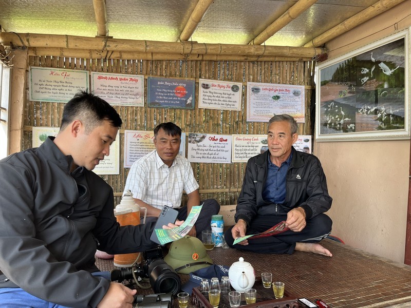
Le Tien Dung, a worker at the Division of Natural Resources and Environmental Conservation under the Xuan Thuy National Park, points to a flock of birds flying from the mangrove forest, telling us: This is the Ramsar dance! We saw 38 black-faced spoonbills return to the park yesterday, and more will probably arrive today.
Phan Van Tiep’s accommodation is the gathering place of the buffer zone self-managed team.
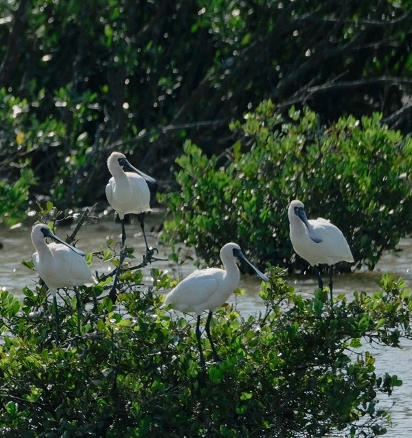
Our visit to Xuan Thuy National Park in Giao Thuy District, Nam Dinh Province, coincides with the bird migration from the north to escape the cold and find food. Le Tien Dung, who has worked here for 25 years, shared that tens of thousands of birds come here from October to April while some species stay until May. Among the more than 200 species of birds in the national park are some species listed in the International Union for Conservation of Nature (IUCN) Red List of Threatened Species (Red Data Book). The black-faced spoonbill is the symbol of Xuan Thuy National Park, with 38 individuals seen this time. There was a year in which as many as 84 individuals were recorded.
Xuan Thuy National Park is a large wetland area with a diverse ecosystem bordering the Red River estuary, the mainland, and the East Sea/South China Sea. The park covers a total area of 15,100 ha and is divided into two areas: a buffer zone and a core zone. The park was formed from alluvium of the Red River mixed with coastal sand dunes, including the three islets of Con Lu, Con Ngan, and Con Mo (Xanh). Alongside the canals are vast flooded flats stretching to the sea dike, where the local people are allowed to conduct aquaculture.
According to Deputy Director of Xuan Thuy National Park Vu Quoc Dat, it is acceptable to implement economic activities according to planning at the buffer zone with an area of 8,000 ha, however cutting down trees, catching birds, or causing harm to the environment is not permitted.
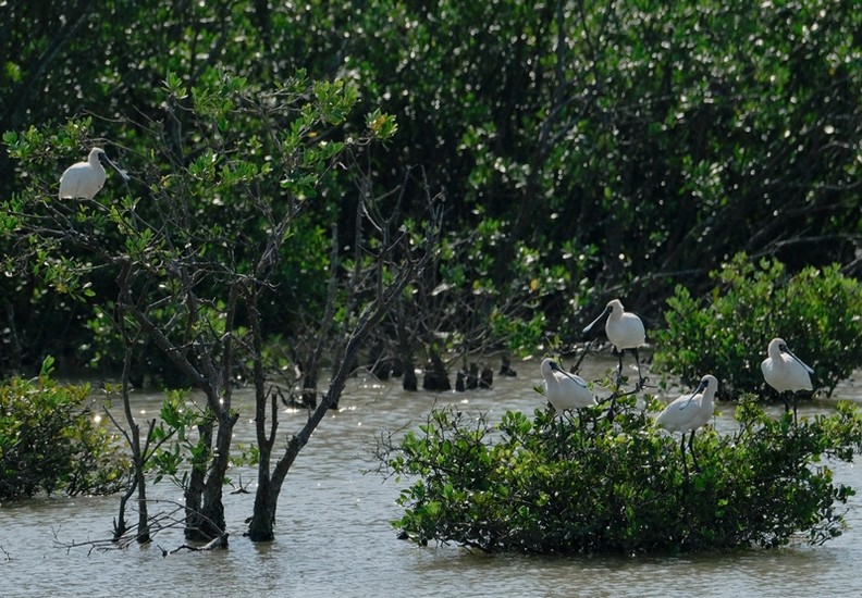
The black-faced spoonbill, an endangered species, is the symbol of Xuan Thuy National Park.
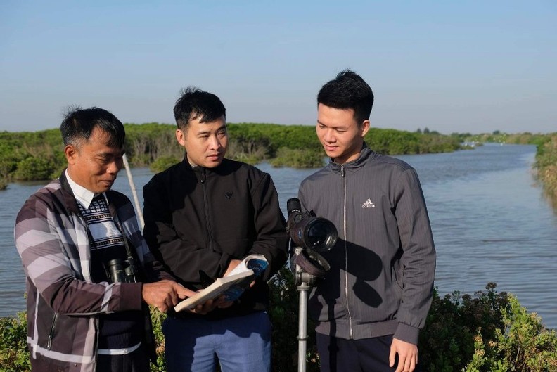
About 3km from the buffer zone is the Vanh Luoc breakwater where a ranger station is located. Spanning from the ranger station towards the sea is the core zone with an area of 7,100 ha, including 3,100 ha of land with forest and 4,000 ha of low-tide wetland, including part of the area of Con Ngan, Con Lu, and Con Mo. These sand islets are separated by creeks, so watercraft is the main mode of transport.
Amid a waft of autumnal cold wind, from the vast sea far away, fleet of birds are flocking to the wetland area to find food. There are flocks of up to hundreds or thousands of birds. Where the buffer zone intersects with the core zone, there are noisy sounds of birds calling each other in the bushes of the dense mangrove forest. Along the beach, several jellyfish as big as a large hat are floundering on the waves, washing up at the foot of the mangrove forest.
Head of the Division of Natural Resources and Environment Conservation Phan Van Truong explained that the wind has changed today, so local fishermen have not gone fishing. Here is home to 120 species of plants, more than 500 species of animals, and 30 species of reptiles and amphibians. Currently, bird protection is carried out effectively here as an internationally recognised area that it is jointly protected by forest rangers, police forces, and border guards.
The core zone is divided into two subdivisions according to terrain, including a strictly protected area (6,000 ha) and an ecological recovery area (1,100 ha). This zone has forests, land, creeks, and mudflats suitable for diving birds, while people are allowed to conduct manual and sustainable sea exploitation as recommended by the Ramsar Convention.
A survey of extensive aquaculture ponds in the buffer zone.
Xuan Thuy National Park was the first wetland in Southeast Asia to join the Ramsar Convention on Wetlands of International Importance Especially as Waterfowl Habitat in 1989. In 2004, the United Nations Educational, Scientific and Cultural Organisation (UNESCO) recognised the park as the core zone of the Red River Biosphere Reserve. The number of bird species here is increasing due to the maintenance of habitat and the strict protection. This is the result of the effective coordination between functional forces and the local people.
Head of the buffer zone self-managed team Phan Van Tiep, who also conducts aquatic farming, said that there are absolutely no restaurants selling birds around this area. If any bird enters the farming areas and gets caught in the net, the farmers must report it to the team to rescue the bird. Households mainly implement extensive farming — a form of natural farming in which seafood feeds on plankton to survive. Last year, Tiep released 400,000 shrimp seeds and a few crabs for extensive farming.
- If you’ve released so many shrimp seeds, you’ll earn a big profit upon the harvest, right?
- Smiling, Tiep slowly says: not as much as you think. Although I released 400,000 shrimp seeds, I only hope to harvest around 200,000.
Life in the buffer zone is silent, with only the chirping of birds and the roar of the sea and the wind. We must pass through a canal to move from Tiep’s shrimp farm to Tran Van Thu’s farm. Within the next ten days, Thu will drain the shrimp pond to harvest the shrimp.
The black-faced spoonbill is the symbol of Xuan Thuy National Park.
As healthy land is for birds crowding, there are many species of birds that feed at night at Tiep’s farming pond. Whenever the water is drained, birds will flock there to find food. Yesterday afternoon, Thu attended a bird rescue training course held at the park’s administrative area. Thu still holds the instruction document in his hand, saying that “The border guards have just given it to me, helping to raise awareness of protecting resources and not hunting rare birds.”
Director of Xuan Thuy National Park Doan Cao Cuong said that after 20 years of construction and development, the park has preserved an intact standard sample of the wetland ecosystem in the Red River estuary while conserving typical animal and plant species of wetland ecosystem, especially water birds and migratory birds. At the same time, the park has implemented scientific research, international cooperation, and environmental education programmes in an effective manner, thereby creating a foundation for sustainable local economic development.
The mangrove ecosystem of Xuan Thuy National Park plays a crucial role in protecting water sources and coastal land in addition to preventing erosion and landslides, contributing to regulating climate and limiting impact of natural disasters. It is also the habitat and breeding place of aquatic species, especially endangered, precious, and rare aquatic species.
The sun fades out. The faint light spreads over the shrimp ponds, casting a red glow on the leaves of the casuarina forest. Far out to sea, flocks of birds are fluttering, creating Ramsar dances. Dung excitedly says: More birds have arrived, and the number will continue to rise today. Tomorrow, we will count the number of birds and take samples to serve foreign scientists who will come to do research.
Ninh Co